
Potential Tropical Development Off Florida's East Coast Could Bring Heavy Rainfall |
Meteorologists Monitor Disturbance with 30% Chance of Strengthening |
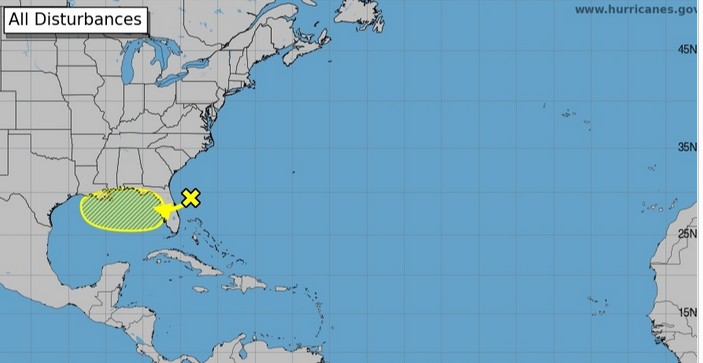 |
An area of low pressure off Florida's east coast is under close observation for potential tropical development this week, with the National Hurricane Center (NHC) assigning it a 30% chance of strengthening into a tropical depression or storm over the next seven days.
As of Monday morning, the disturbance is generating disorganized showers and thunderstorms. Forecast models suggest it will move westward across Florida within the next day or so, entering the northeastern Gulf by late Tuesday. Conditions in the Gulf appear favorable for further development later this week.
While it's too early to determine the system's exact path or strength, residents should prepare for a wet week ahead. Heavy rainfall is anticipated across parts of Florida and the north-central Gulf Coast starting mid-week, raising concerns about localized flash flooding.
In the Tampa Bay area, the forecast includes periods of heavy rain and thunderstorms. For instance, on Monday, isolated showers and thunderstorms are expected before 11 a.m., with more widespread activity in the afternoon. High temperatures are projected near 92°F, with heat index values reaching up to 103°F. Similar conditions are forecasted for the following days, with high chances of precipitation and potential for significant rainfall amounts.
Residents are advised to stay informed through official channels and take necessary precautions, especially in flood-prone areas. The situation is evolving, and updates will be provided as more information becomes available.
**Frequently Asked Questions:**
**What is the likelihood of the disturbance developing into a tropical storm?**
The NHC currently estimates a 30% chance of the system strengthening into a tropical depression or storm over the next seven days.
**How much rainfall is expected in the Tampa Bay area?**
Forecasts indicate periods of heavy rain and thunderstorms, with potential rainfall amounts between a half and three-quarters of an inch on Monday, and similar amounts in the following days.
**What precautions should residents take?**
Residents should stay updated through official weather channels, avoid flooded areas, and be prepared for potential flash flooding, especially in low-lying regions.
|